Exploring Life

Geocaching, geocoins and the many roads of life.

This is made up of stories from my caching and my reviewing.  It is a collection of those along with comments and thoughts.  Photos, and maps of some adventures and lists of some of the oldest caches.

Filtering by Tag: Android

Maps, more Maps, and a Crippled App.

It has been a while, nearly a month or more, so it is past time that I get back into things.

The most notable change in the last month?  Maps.  Many will notice a change.  Groundspeak does not claim that these are an upgrade, but a change. 

Why the Change?

The maps came about when Google instigated a new policy that they announced last fall that they would start charging the heavy users for use of their map API.  Well groundspeak delayed as long as they could before they had to actually start paying Google.  So they dumped the maps for new ones. The change is not everywhere, but in many places.  I expect that it will expand through other services (waymarking, cache creation pages, etc).  They just pulled the heavy users at the moment.  Every cache page was pulling up two Google maps.  I had noticed a month or so ago that the smaller map high on the page was no longer Google, but did not give it any thought at that time.

The only actual statement of cost that I have heard from a lackey is that it would cost "a few million dollars" and maybe more.   I have heard numbers from different people tossing about $10,000 to well over $3 million.  The $10,000 number is the low price of licensing through Google.  Groundspeak is a very heavy user, that averages over 2,000,000 hits per day.  I would guess that on big holiday weekends, that number may be 150-200% of that number, and the game is only growing.   I will stick with the "few million dollars" as only Groundspeak and Google know what the usage is and what the costs may be.

That being said, how many users are there? and income from them? This is only conjecture at this point.  Cacherstats.com tells us that there are 165,000 cachers that have ever found over 200 caches.  There may be 5,000,000 users, but most are casual, or do not log.  I decided to say only 50% are paying members.  I am sure a few players under 200 finds are premium members, but many over 200 have left the game in the past decade, and found new hobbies. (at least around here) or are a family with many accounts and only one or two premium accounts.

So that leaves us with 85,000 paying customers. That would be $2.5 Million dollars of income.  So paying millions or even one million in fees to Google hurts the company severely.  Groundspeak has a number of programmers, Customer Service, Legal Council, server and bandwidth costs.  They have worked hard to improve the game, and laying off 1/3 to 1/2 of its staff would not be helpful to the game.

What Happened?

There are a few things to look at.  There are three main maps that were on Geocaching.com that I recall.  The old map page, the "beta" maps, and on the cache page.  Those were the big hits (I am guessing). 

Well the old map page went away.  Groundspeak had been phasing it out for a while now, and getting the new maps ready.  There was no reason for them to continue, and keeping it with a new map set would have meant reprogramming the page.  No big deal, but it was at the end of its life, so it was left to Die.  This had a side effect apparently (see below).

The Beta maps became the new map page.  In the upper right corner is where you can shift between map layers.  Personally i do like the OpenStreetMaps. 

For satellite views?  I moved to Google Earth, again.  There are instructions on how to use them here. http://www.geocaching.com/about/google.aspx  In Google earth I have KML files of Indian Lands, Wilderness areas, National Parks, and i get a cool 3D view.   Makes it easy to decide if I want to hike if I can see how high the hills actually are.  I forgot how cool this feature really is.

Open Street Maps

OpenStreetmapsI find these really cool, mostly because I find maps are cool.  Plus I get to work on them and add to them.  I always hate maps that do not have roads, or are mission places.  I went into Springville, and have added many roads, train tracks, churches, parks, etc.  It is a fun project to kind of play with.  The bright side.. you can make your maps better.

It took me a bit to figure out, but for the most part it is pretty simple.  There are a number of tutorial aids to explain how to do it. 

I am not sure if I understood correctly, but someone told me that when groundspeak gets its own tile server up and running that OSM will be set as the default.  Hopefully that is true, Mapsource is not bad, but OSM is far better. 

C:geo
When the site was upgraded and the old map page was tossed into groundspeak refuge pile for old web pages there was a side effect. C:geo the site scraper was tossed into turmoil.  Apparently from reading their website and emails from one of the people working on the project they pulled from the old map.  Getting the location and type of caches from that page.

Well with that map gone, they cannot do that any more.  The new map operates in a different way.  They are working on a fix, but they will be up to 150 feet off at times (50m), depending on your view.  It also will not tell you what type of cache is there at that location.  

You can load a PQ into it and it will work fine (I did not try that).  I pulled it off my phone yesterday in frustration.   I may reinstall it, but it is too cold to go caching right now (snow is on the ground from this last week). 

 Here is the thing. GC.com did something we were afraid for some time now. Live map was changed and old maps was also removed. c:geo relied on this old maps to get data.

In other words they felt that the old maps (the page not the Google maps) were going away.  Yet apparently no plans were in place to work on the new set.  Originally carnero (the original developer) was looking into the API before stopping development of c:geo and turning it over to a group.  The new group has repeatedly said that the API would harm the non-premium members.  So they chose not to dive into it. They

Statement on the live maps and development from them. - Here is a clip from that

In a fast, short and not good online meeting for c:geo people come up with this. Live map will come back, but it will never be the same again. It should be fast with 2 problems.
  • all caches on live map will be inaccurate (+-50m or so), depending on a zoom level
  • type of all caches on live map will be unknown
When a cache will be opened all details can be loaded, including type (traditional, multi, ...) and exact coordinates. Approximate time to implement this is something between 2-6 weeks.

Well, they made the decision.  I am going to play with other Android services that use the API.  I may review a few of them here.  I have not looked at anything other than c:geo and the groundspeak app in the last year or more.

This is from the API Statement Read more here

What would change with the API?

- c:geo only for premium members
- no support for OpenCaching or other platforms than gc.com
- Groundspeak-ads

Also there are problems with development:
- development would take 2-4 months to implement the API
- during this time there would be only access to a testing-server, no nightly-builds
- devs are using the development-build for caching
- the API requires a private key for the app. But c:geo is open-source. There are a lot of independent developers, but only one would get the key - all other developers wouldn't be able to test what they do
- c:geo no longer open-source
- only few core-developers
- much slower development

Now What?

So that is where we are now.  Groundspeak and C:geo are trying to decide what is next, people are trying to figure out the maps, and geocaching goes on.  I hope to get out and make a day of it soon. If the snow will go away long enough for me to, or I take a trip to get away.

See you at the cache, and remember to have fun.


C:Geo Going Away

For those who did not see the message yesterday, the writer of the c:geo is closing the doors, and dropping out of caching, and he tosses all the blame on Groundspeak.

Really?   That makes little/no sense to me.  c:geo is part of the group that is testing the API with groundspeak.  They are getting what they wanted, a chance to operate within the rules and be a legitimate program. 

It just seems fishy.  He gets in the door to run the API, and he gets tired of caching and walks away.

He knew there were problems...

During the c:geo development, I had to keep my eye on GroundSpeak. They didn't like c:geo. Ive read their TOS many times and I saw some parts there with the potential to eventually kill c:geo.

With a ban for a while in the forums, he knew that Groundspeak was displeased.

This also caught my eye

I've decided to leave geocaching (the game) behind and find something else to do for fun instead. I won't support such company anymore. And that also means it's the end of the active developement of c:geo. It will stay on Market, unless/until it stops working due to changes on geocaching.com. Sources will be available on github as they are right now.

He is tired of caching and the mess I am sure.

Some have said that Groundspeak is actively trying to destroy it.  Why?  They know it has brought people into caching.  I have seen many conversations about it, I moderated the Android forums at Groundspeak for a while and a lot of discussion took place.  I saw no active discussions to "kill" android behind the scenes.

On the contrary, there has been a major overhaul of the site planned for the last year or more.  Rewriting the code for entire sections, adding more features.  If someone is pulling from the site and Groundspeak is upgrading, then you will get burned.  Each monthly update created a headache.

The answer .. use the new API.  I am sure that came with certain rules.  If you use the API you will have to follow certain rules.  That could mean, some activity that C:geo was engaged in would have to stop.  It would be able to survive the monthly updates, but some changes would have to be made.

My summary

I don't know for sure.  I am betting that he did not want to rewrite the entire code.  Did not want to deal with the hassle of a complete top to bottom shakeup.  Especially if he was tired of caching.  Why put energy into something that you don't have an interest in.

Groundspeak will continue to upgrade the site, and it will break soon.  People will cry, and other programs will jump up to replace it, some on the new API and some on the old.  

People seem to be crying to Groundspeak, but they are the ones that are opening up to others with an API development.  They are not the ones that threw in the towel and walked away.

Android Geocaching App - Part 4

I was looking for as much information as I could.   There was not a lot that I could find but I can take the time to help you figure out how to load information into your geocaching app.

First you need a gpx file.  This is most easily done with one of two options.  The two options require a premium memberships, and some understanding of pocket queries.

You need to create a pocket query for what you are looking for.  There are a number of options to do that.  If you go to your profile page and select the "pocket queries".  Take the time to create a pocket query for the area that you want. There are a number of options to make a query, I will not go through them all here.  You want your file to be available for download.

The other would be to create one through another program through GSAK.  Then upload that file to GSAK. In that case you can go to your 'my profile' page, and and to your saved gpx files.  Upload the file there.

When you are ready to download the file go to your application and go to the first screen titled "Search" at the top.  Select menu and click on your saved caches button.

You can then go to a screen with Download Pocket Queries, you will get a menu of all the pocket queries that you are able to download.  Select the one that you want to download. It will give you some information on the file, and you can compete the download.  It will just take a while do download, and then transfer the information into the program.  Into a format that can be used. 

You can also take the time to load a file from your computer.  This should allow larger files. I am not sure how yet.. but it is coming.

It took about 15 minute to process a 500 count file.  With the new 1.01 update it took only a minute or two to do the same amount.

Once you have it down you select your saved caches (from the menu) it will open all of those files.  Voila.. you have a lot you can use as your drive around and offline.

Android Geocaching App - Part 1- Initial Impressions

Android Geocaching App - Part 2 - Searches, Trackables, and Settings

Android Geocaching App - Part 3 - Geocache Navigation

Android Geocaching App - Part 4 - Loading Saved Files

Android Geocaching App - Part 5 - Final thoughts

Groundspeaks Geocaching Andriod App Part 1 - Initial Impressions

Well here goes the run with Groudspeak's app.  This will be multiple parts focusing on the Android app and how it works, and what you can expect from it.

First I should point out that I use a Sprint Hero running 2.1.  I have tried a number of other apps, all with their ups and downs. I did not pay money for any of them.  I stuck with the free versions, or apps that were free.  So the chance to jump on the app was great for me.  We were told that it was coming out sometime during the week, so I would check the app store every few hours.   No luck at all.

Loading

Finally the app appeared in the store.  I downloaded it and it said there was 50-100 dowloads at the time. So woo hoo here I go off to the great beyond.  <poof> $9.99 vanished from the checking account and a few minutes later I was downloading.

No problems on the load.  Well there was one. Where I was at work had a poor download speed.  Well I guess there was not hurry.. I was at work after all.  Not much I could do there.

Impressions

It was running nicely.  I liked the splash screen, it reminded me of a place I camped a few months ago.  It smoothly ran me to the screen that asked me what I wanted to do: Find geocaches, different searches, and a trackables button. 

I zoomed through a number of screens, I had it search for the nearby caches and came up with a list.  Skimmed through a number of caches on the screen.  I clicked on one and the cache listings came up.  There were many different options that appeared, I looked through them and was able to get all the information from the cache page that you see on a page.  Description, hints, and other info. 

Clicking Navigate took me to a screen that let me look at the map of the area... with a line to a nearby cache.  The one at the destination.  It was a simple Google map. 

I took it out for a spin and found a cache.  I was happy with how smoothly it worked.  There was no delay. and I quickly noticed that on the map screen was a circle.  I eventually figured out that the circle around the dot that represented me was the margin of error.  It was pretty small, but there were times (inside and near buildings) that I could make it grow.

When I selected the option to actually navigate with the compass (from the menu screen) it took me right to the cache.  I am getting really good accuracy.  Far better than I expected, especially after I read about the iphone 3g gps issues.

Then it was a simple matter of logging the cache.  There are two options.  One that let me submit the cache as a field note, or just submit the log later.  Either could be a good option.  You may want to publish things later and write a longer note, or you may wish to do ir right then.  Depending on your skill with typing logs, or wanting to make it bigger later.

Final thoughts (part one)

It worked really nicely and I was happy to get my first cache with it.  I found two more that night, it worked smoothly and I did find some other little tricks that I will bring up when I continue with this.  But I would recomend it.

On that note.. some users are having issues with a few models.  Android phones often have a special UI over the Android operating system.  My Hero runs one called HTC sense, and also has some Sprint UI built in.  The Droid X has had a number of issues.  So you will spend some time working around them until the next update comes up.  Apparently they all have work arounds but you will want to be aware of it.


Android Geocaching App - Part 1- Initial Impressions

Android Geocaching App - Part 2 - Searches, Trackables, and Settings

Android Geocaching App - Part 3 - Geocache Navigation

Android Geocaching App - Part 4 - Loading Saved Files

Android Geocaching App - Part 5 - Final thoughts

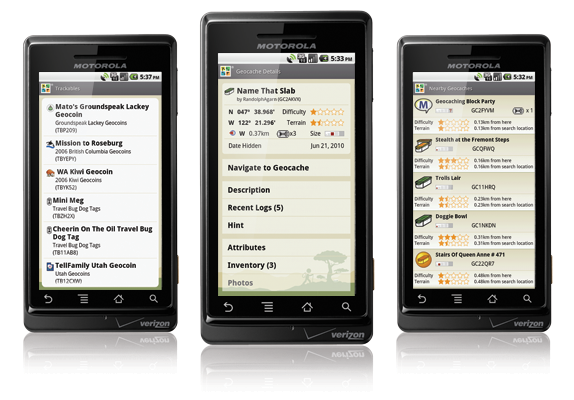
Android app has arrived.

After a few months of waiting and moderating the Android forum on geocaching.com the moment finally arrived.  This afternoon the Android app appeared on the market.

I have tried a number of the other apps out there, and was always left kind of bummed at almost all of them.  From the geocaching.com websiteThis afternoon I logged on and finally had the app.  It took me a few seconds and it was on my phone and then I had to wait a few hours for quitting time.  Then off i went. The first cache was a bust.  but I could not find it anyway, and the second I went right to it.

I have been pretty please. It appears I have the ability to log it to my field notes, so i can make a longer cache note later, save a batch and upload 4-5 logs, or upload each log as I go.

I really liked how it looks and its ease of use. I was worried with all the other stuff out there that this one would not measure up.  It does.  and I am happy that is does.   It is the favorite of the ones that I have played with .

Powered by Squarespace. Home background imaged by Dick Nielson.  This blog is for my fun and enjoyment.  I have been known to receive a t-shirt or coin as a gift at times, but not pay for my ramblings.   No one is dumb enough to actually pay for that.  However if you are that dumb and wish me to speak on your behalf, or issue a statement on your behalf, let me know.  I can be bought.